
Trails at Crosstown
About
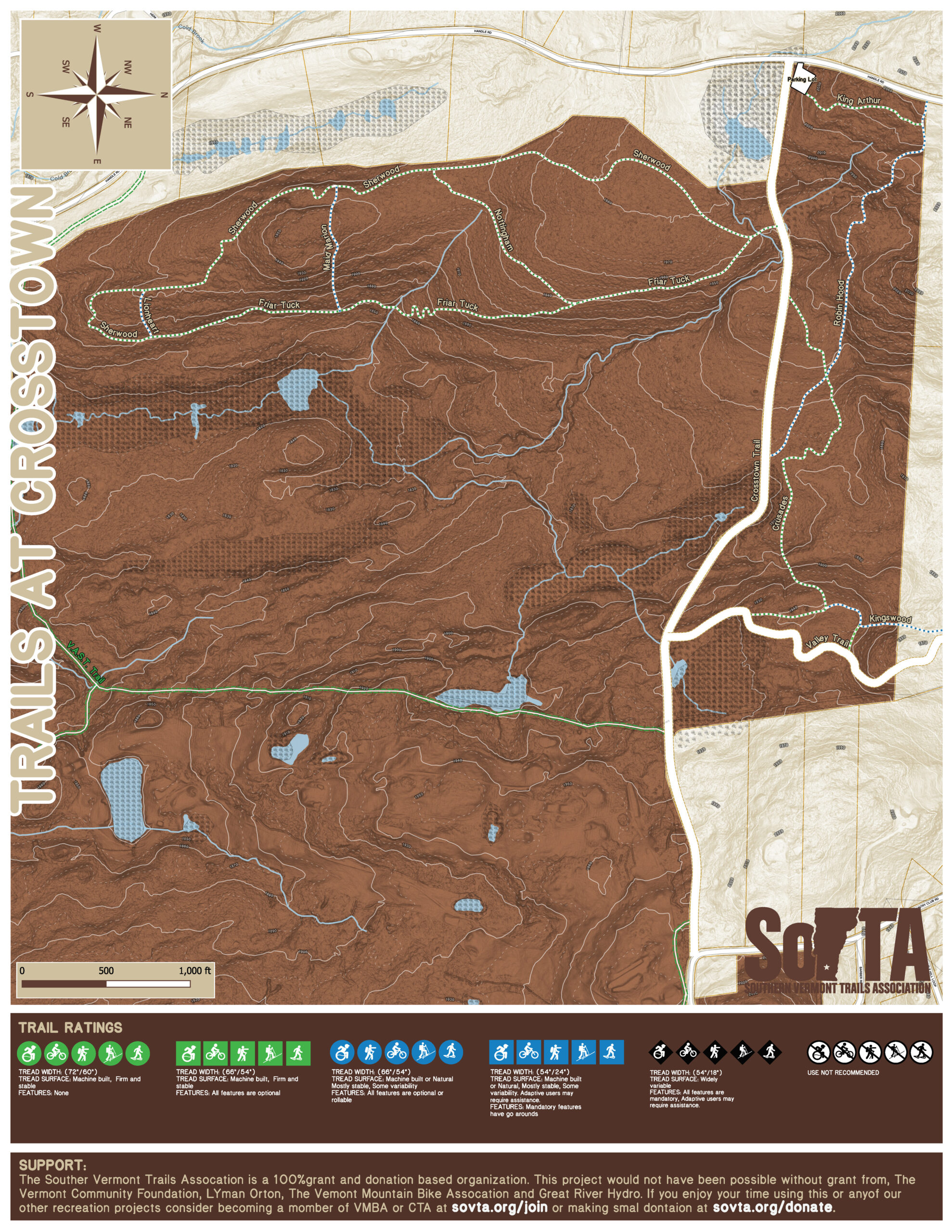
The Trails at Crosstown is a four season adaptive/family friendly multi-use trail pod on land owned by Mount Snow with SoVTA providing stewardship the ongoing improvements and maintaince. Crosstown Trail is a Town of Dover right of way and is maintained by the municipality.
Over the last 3 years we worked on revitalizing the trails to improve their weather resilience so the trail treads are less prone to standing water, erosion, sediment transfer to sensitive habitats and reduce trail closures. We have also worked to improve adaptive/family friendly access to the south side of the pod and have made select improvements to north side to remove adaptive pinch points and rock armor persistent wet spots.
This work was made possible through a $13,000 sustainability grant from the Northern Forest Center, a $7,000 VMBA Trail Grant and a $4,000 grant from the Kelly Brush Foundation with Mount Snow contributing materials and some time of the mountains trail crew.
The trail pod is divided into to two areas by Crosstown Trail, The North Side and South Side. The South Side features our easiest most adaptive/family friendly trails with two short natural trails. The north side features more typical New England technical trails with roots and rocks.
Trail descriptions and routes: South Side
Sherwood Forest:
Distance: 1.10 Miles, Elevation +-125ft
The trail is an green adaptive/family friendly bi-directional multi-use trail that has mix of gentle flowing rollers, banked turns and easy to navigate natural rooty sections that gently looses elevation from the entrance by the Crosstown Trail to its end at Friar Tuck with a small climb after Nottingham.
Friar Tuck:
Distance: 0.75 Miles, Elevation +-135ft
The trail is an green adaptive/family friendly bi-directional multi-use trail that has mix of gentle flowing rollers, banked turns and easy to navigate natural rooty sections that gently looses elevation from the entrance by the Crosstown Trail to its junction with Maid Marion.
Nottingham:
Distance: 0.35 Miles, Elevation +-50ft
The trail is an green adaptive/family friendly bi-directional multi-use trail that has mix of gentle flowing rollers, banked turns and easy to navigate natural rooty sections that gently gains elevation from Sherwood to just before Friar Tuck where it looses a small bit of elevation.
Maid Marion:
Distance: 0.20 Miles, Elevation +-70ft
The trail is a blue single track bi-directional multi-use trail that has steep climb from Sherwood then descends down to Friar Tuck. Adaptive user may require some assistance to navigate narrow sections of trail. It is generally best to start from, Sherwood but it can be done both ways.
Lionheart:
Distance: 0.10 Miles, Elevation +-40ft
The trail is a blue single track bi-directional multi-use trail that descends from Sherwood down to Friar Tuck. Adaptive user may require some assistance to navigate narrow sections of trail. It is generally best to start from, Sherwood but it can be done both ways.
Trail descriptions and routes: North Side
King Arthur:
Distance: 0.20 Miles, Elevation +-50ft
The trail is a green natural single track bi-directional multi-use trail that climbs to its connection with Robin Hood. There are only natural rocky and rooty single track available from this trail. Advance adaptive users will be able to navigate the trail.
Robin Hood:
Distance: 0.50 Miles, Elevation +-190ft
The trail is a blue single track bi-directional multi-use trail that has several rock slabs, water crossings and steep rooty sections.. Adaptive user may require some assistance to navigate narrow sections of trail. It is generally best to start from, King Arthur but it can be done both ways.
Crusades:
Distance: 0.50 Miles, Elevation +-118ft
The trail is a blue single track bi-directional multi-use trail that has several awkward rooty sections.. Adaptive user may require some assistance to navigate narrow sections of trail.
Kingswood:
Distance: 0.20 Miles, Elevation +-100ft
The trail is a blue single track bi-directional multi-use trail that descends down to the Valley Trail and the Kingswood Development. Adaptive user may require some assistance to navigate narrow sections of trail. It is generally best to start from, Sherwood but it can be done both ways.