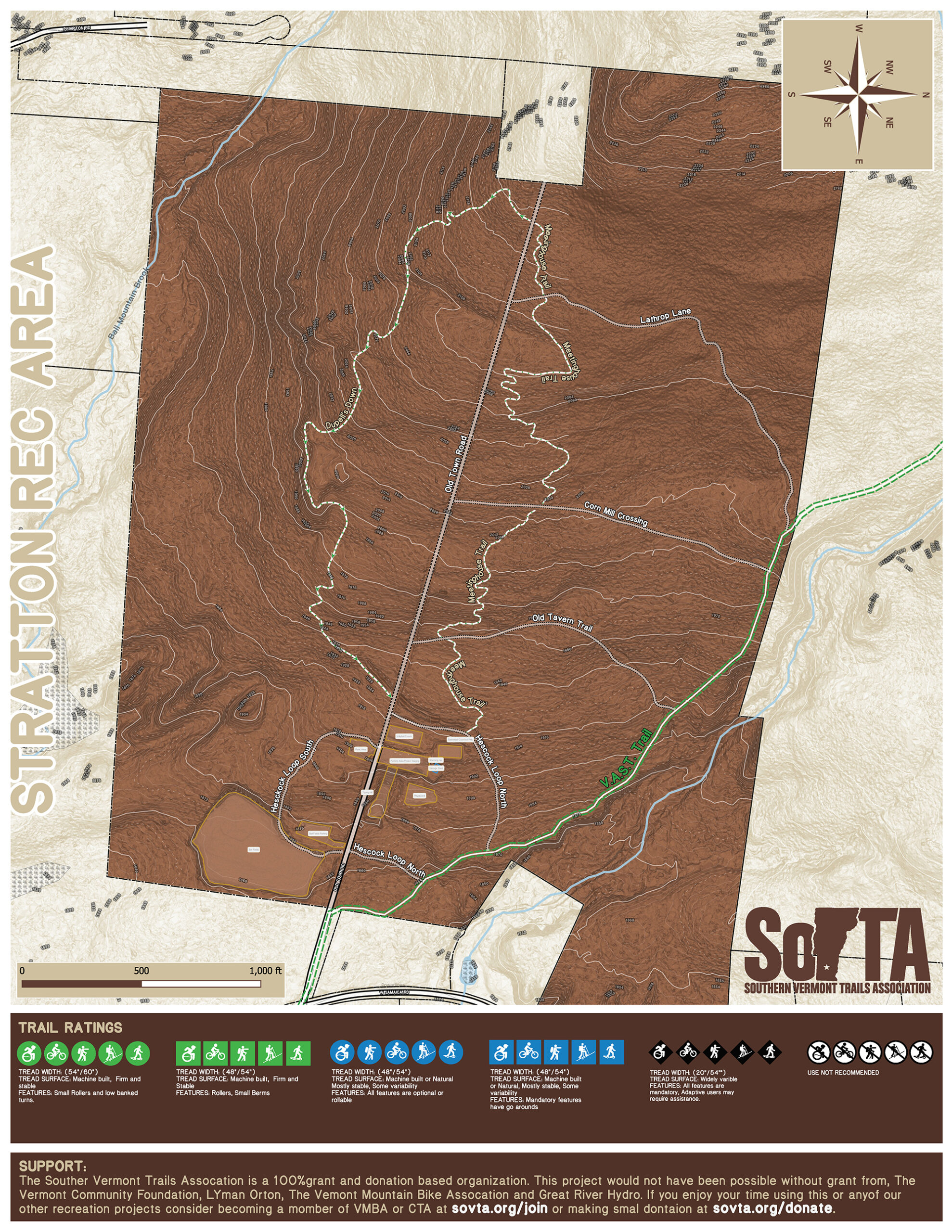
IMG_1502
Summer

In summer we have many hiking, biking and running trails. Please have a look at our maps, the descriptions of the zones and trails. These zones and trails would have not been possible without a partnership of the Town of Dover, The Dover Town Forest Conservation Commision, Mount Snow, USFS and the private landowners of the Dover area. Please no unsanctioned work is permitted. SoVTA has invested thousands of hours of planning, mapping and working with land managers to have access to these areas. If you are interested in being able to do work please contact SoVTA, become a member and we can get you trained and covered under our insurance. We would also like to thank our sponsors which without their support we could not built and continue to expand the trails and backcountry touring zones. Please take a look at our sponsors page and show them some love.

GPS Map App
Emergency Location Markers (ELM)

SoVTA has partnered with Avenza Systems Inc. To provide an offline GPS mapping application so you can view georeferenced maps on your phone. Digital maps are no replacement for having a printed copy and using a compass but is just another tool you can use to aid in you backcountry adventures. You can download the app from the Google Play Store and the Apple Apps Store. You can then search for SoVTA maps in the app or download them here.

SoVTA has in conjunction with Dover Search and Rescue, Dover Emergency Services and State Emergency Services developed a Emergency Location Marker system that will aid emergency services in being able to locate you if a emergency situation occurs. Markers are located at all trail intersections and the top and bottom of all Backcountry Touring Zones. Please study the maps and mak mental notes of where you are located when you are out in our network. You can use the number on the sign that is closest to your current location to aid in Emergency Services determining your location in the network.

Maps
Dover Town Forest (opening summer 2022)
Crosstown

The Dover Town Forest trail and backcountry Touring network is made possible through a partnership between the Dover Town Forest Conservation Commision, the Town OF Dover, The USFS and SoVTA. There are currently four backcountry touring zones:
Baby Town Frolic: 
Is a open low angle zone good for low snow and beginners.
Chutes & Ladders:
Has tight chutes and open areas that gets steeper the lower you go.
Grandma’s:
Is a short moderate zone that provides a connection to the Chicken Little zone Via the Andy’s Way Skin track.
Chicken Little:
Is a zone that good for advanced riders and skiers that has many steep sections with numerous log rides and boulders. 

The Crosstown Trail network is made possible through a partnership between Mount Snow, the Town of Dover and SoVTA. In winter the whole network is open to hiking,cross country skiing and fat biking. Please be aware the part of the Crosstown Trail is shared with the snowmobilers of VAST. Safety is a primary concern on these shared stretches of trail. Snowmobilers cannot hear, and frequently cannot see, skiers and snowshoers before they come upon them. When skiing these shared stretches stay alert and be prepared to step off the Trail at any time to allow snowmobiles to pass. Ski single file and to the side of the snowmobile trail. Keep dogs leashed.  SoVTA grooms two loops:
Sherwood Forest to Friar Tuck:
This loop is good for beginners to intermediates.
Sherwood Forest to Friar Tuck:
This loop is good for intermediates.

The Ridge (Proposed)
Blue Brook Basin (opening summer 2023/2024)

The Ridge project area is a project that is made possible through a partnership with the Town OF Dover, The USFS and SoVTA. For the most current information please visit https://www.fs.usda.gov/project/?project=53706. This area will be one of our largest, highest elevation and remote zones in the SoVTA network. 

SoVTA has partnered with Avenza Systems Inc. To provide and offline GPS mapping application so you can view georeferenced maps on your phone. Digital maps are no replacement for having a printed copy and using a compass but is just another tool you can use to aid in you backcountry adventures. You can dowload the app from the Google Play Store and the Apple Apps Store. You can then search for SoVTA map in the app or download them here.

Bulls Bowl (opening summer 2024/2025)
Cooper Hill (opening summer 2024/2025)

SoVTA has partnered with Avenza Systems Inc. To provide and offline GPS mapping application so you can view georeferenced maps on your phone. Digital maps are no replacement for having a printed copy and using a compass but is just another tool you can use to aid in you backcountry adventures. You can dowload the app from the Google Play Store and the Apple Apps Store. You can then search for SoVTA map in the app or download them here.

SoVTA has partnered with Avenza Systems Inc. To provide and offline GPS mapping application so you can view georeferenced maps on your phone. Digital maps are no replacement for having a printed copy and using a compass but is just another tool you can use to aid in you backcountry adventures. You can dowload the app from the Google Play Store and the Apple Apps Store. You can then search for SoVTA map in the app or download them here.